

Time series of aerial photogrammetry data
Bayan Shaeri and Yuhao Lu
Our 2025 open photogrammetry data release offers the entire data archive (~140 GB), processed from over 3 TB of images, providing high-resolution, time-series records of built structures and vegetations. This release builds on our 2024 work with a more streamlined, reproducible processing workflow. All datasets are using the EPSG 32614 projection.
The open data archive includes:
Georeferenced point clouds: dense 3D reconstructions (.las) from photogrammetry data
Derived Digital Surface Model (DSM) rasters: gridded (.geotiff) elevation surfaces representing the “height” of visible ground elements (trees, buildings, etc.)
Orthorectified true colour (RGB) and multispectral (near infrared, red, red edge, green) mosaics: stitched, georeferenced imagery (.geotiff) for computing spectral indices (e.g., NDVI).
The open data covers UM’s Fort Garry campus (one complete scan in 2024, and monthly scans of its core area from May to November in 2025), the Sylvan Studio site (2025), Alexander Docks (2025), Southwood Circle development area (2024-2025), Kings Park (2024), and Transcona Bioreserve (2024).
We hope these open datasets can support both remote sensing research by offering large training data samples, and design-informed landscape analysis and representations by enabling measurement, visualization, and comparison of fine-scale change over time, from canopy growth and seasonal dynamics to ground surface variation, site disturbance, and the performance of interventions.
URLs to access these datasets are at the bottom of this page.
Acknowledgement: This release will not be possible without the trust and support of the SIEF grants and its committee (#2023-23 and #2024-14), the URA program, and the University of Manitoba Grex High Performance Computing Centre (RRID:SCR_026342).
The University of Manitoba Fort Garry Campus (core) scan from May to November 2025.
Near-Infrared Band
True Colour Orthomosaic
Digital Surface Model
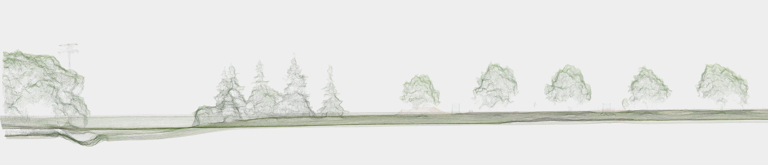
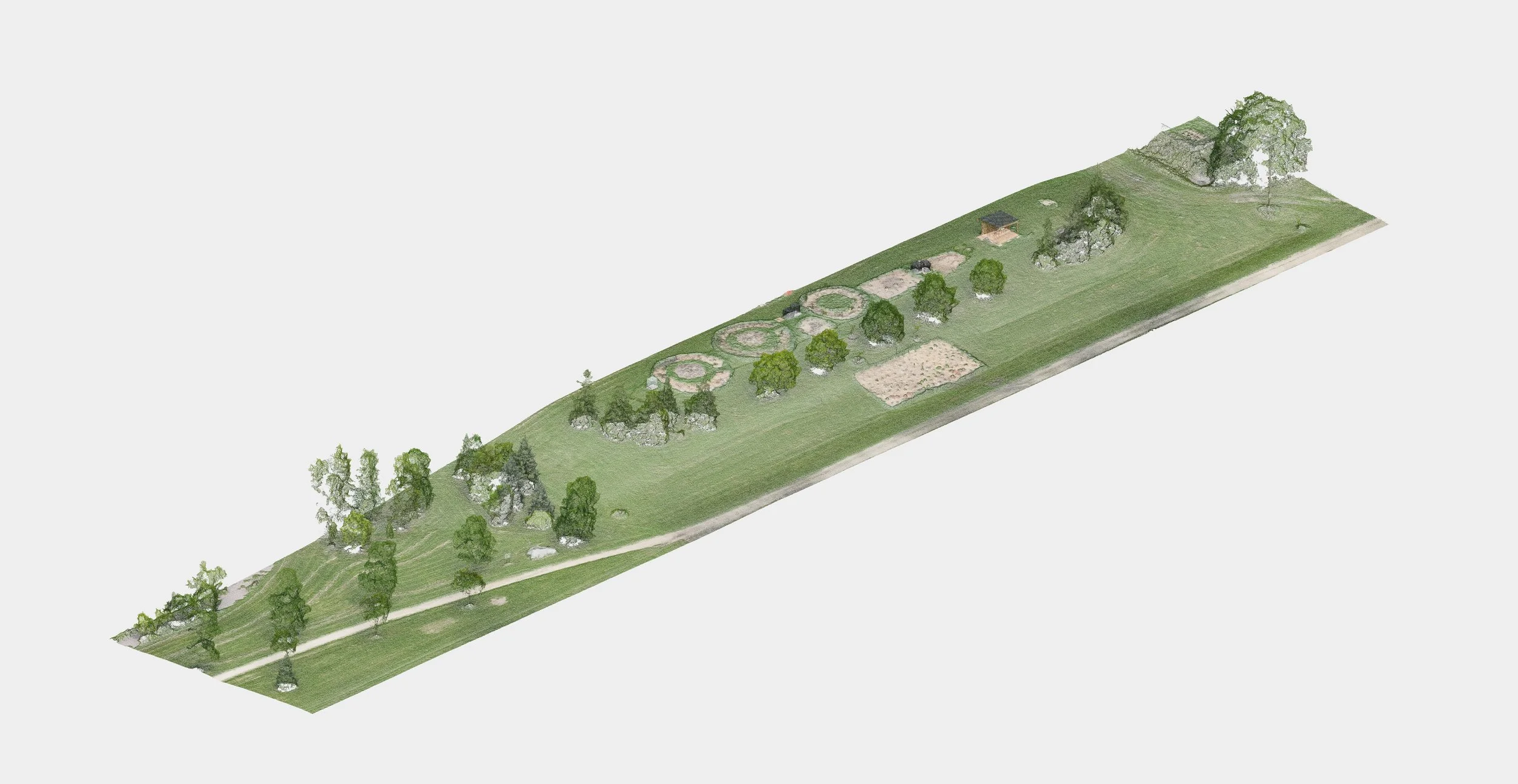
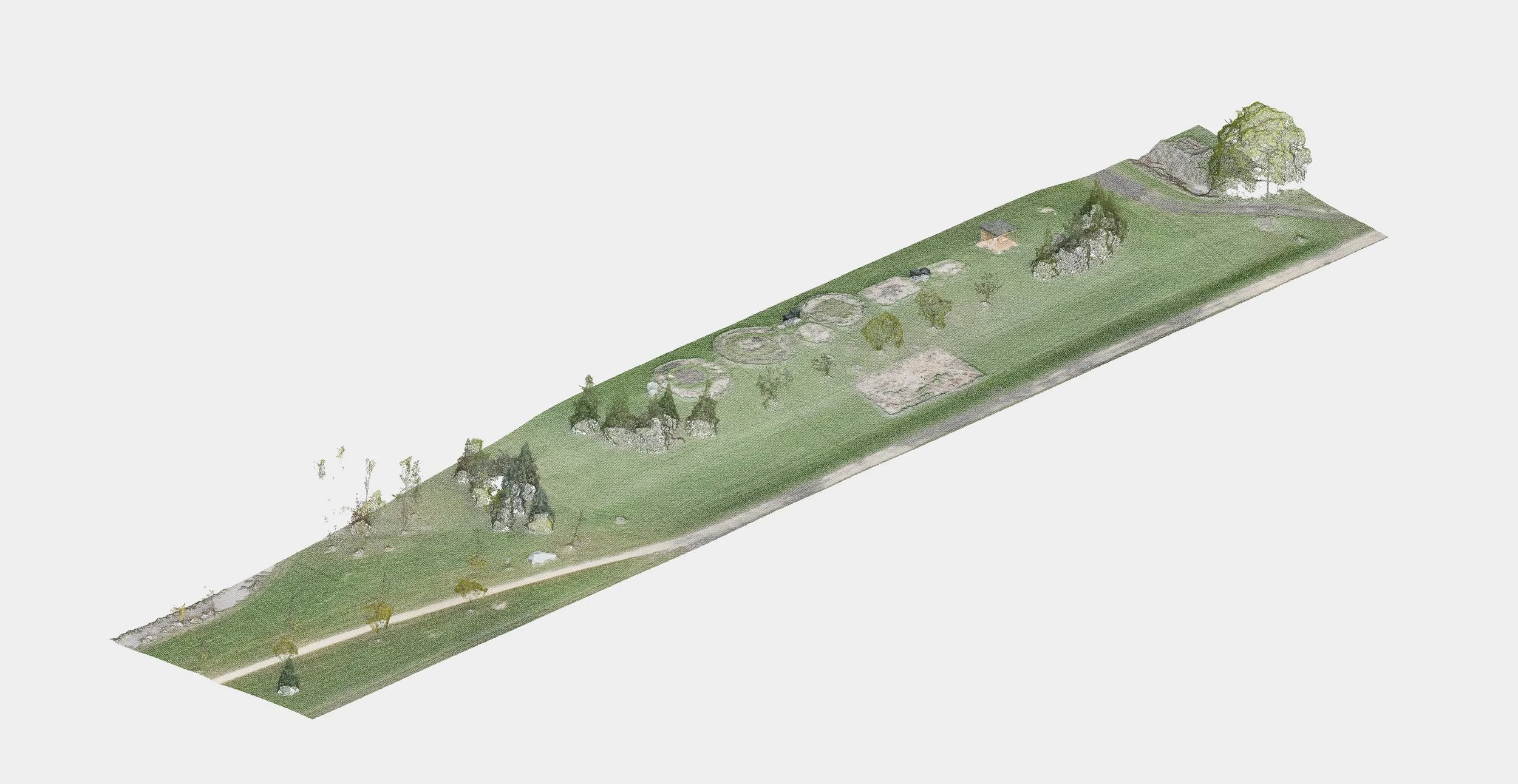
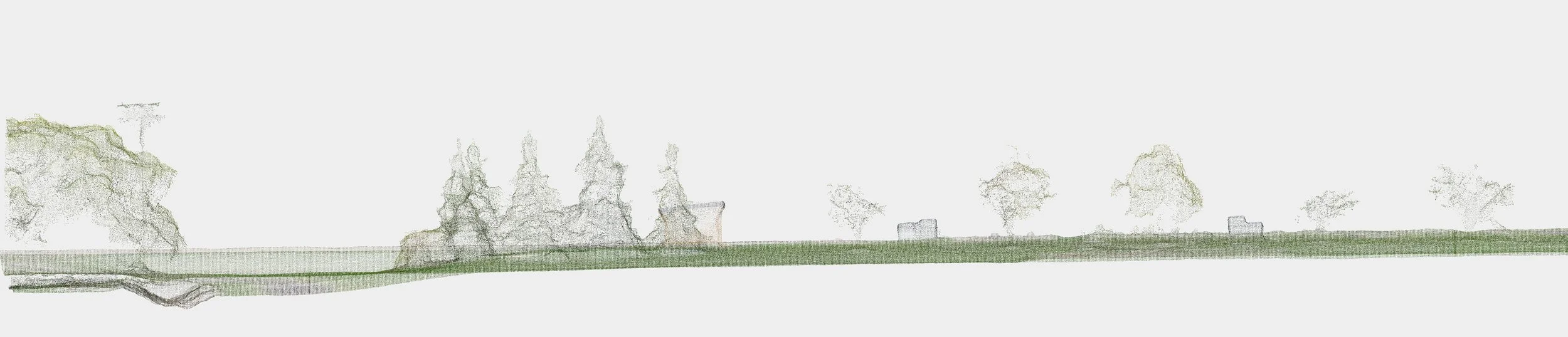
The Sylvan Studio site is an initiative by department colleague Kamni Gill to offer students hands-on learning opportunities in landscape architecture. We documented the site condition over the summer of 2025.
Can you spot the shed?
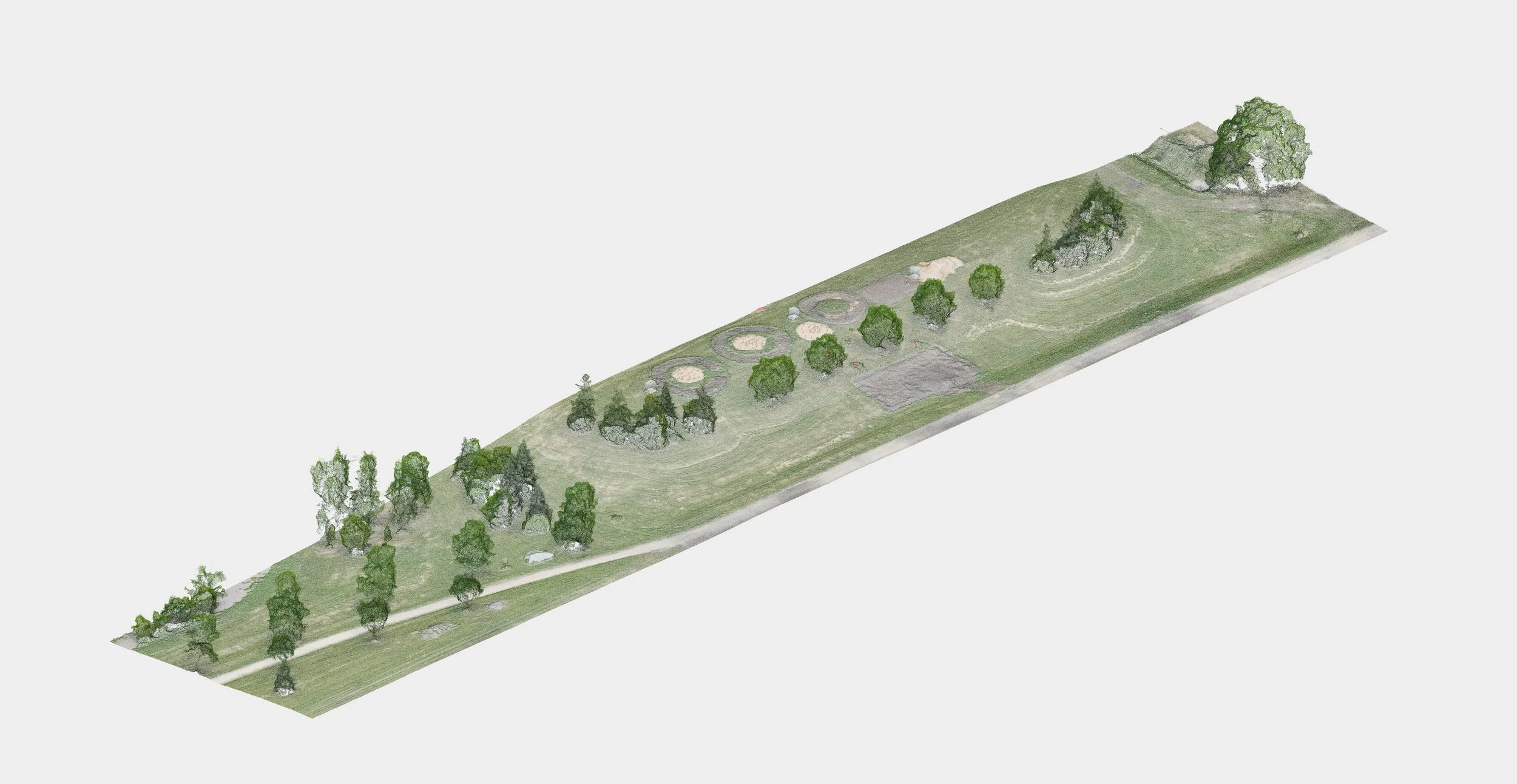
June 16, 2025
August 27, 2025
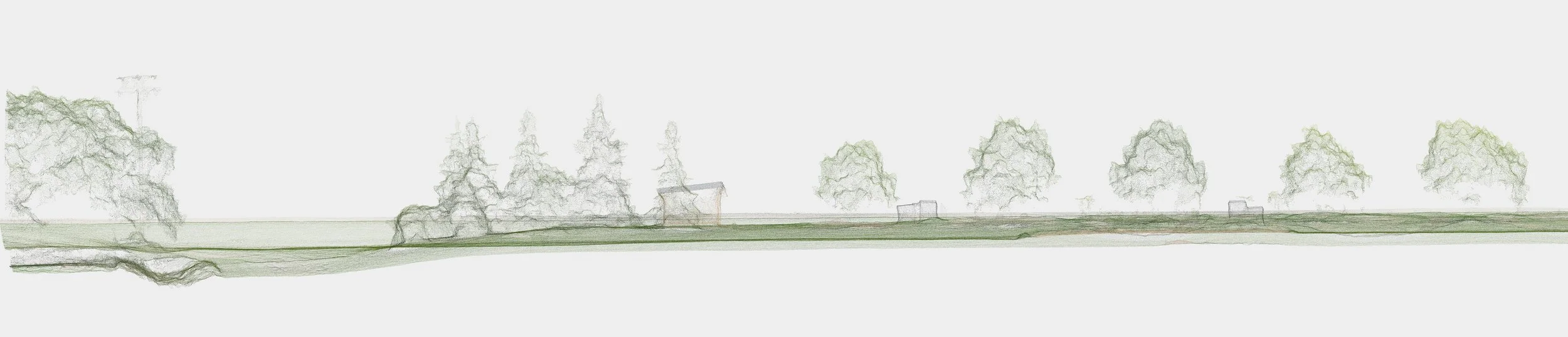
October 17, 2025
Point Cloud
To access the entire archive of point cloud and other derived datasets:
-
RGB
2025 May: https://object-arbutus.cloud.computecanada.ca/scan/F_20250509_1_PC_RGB_GCP.las
2025 June: https://object-arbutus.cloud.computecanada.ca/scan/F_20250616_1_PC_RGB_GCP.las
2025 July: https://object-arbutus.cloud.computecanada.ca/scan/F_20250723_1_PC_RGB_GCP.las
2025 August: https://object-arbutus.cloud.computecanada.ca/scan/F_20250827_1_PC_RGB_GCP.las
2025 September: https://object-arbutus.cloud.computecanada.ca/scan/F_20250919_1_PC_RGB_GCP.las
2025 October: https://object-arbutus.cloud.computecanada.ca/scan/F_20251017_1_PC_RGB_GCP.las
2025 November: https://object-arbutus.cloud.computecanada.ca/scan/F_20251119_1_PC_RGB_GCP.las
Multispectral (Green-Red-Red Edge-Near Infrared are band 1 to 4, respectively)
2025 May: https://object-arbutus.cloud.computecanada.ca/scan/F_20250509_1_PC_MS_GCP.las
2025 June: https://object-arbutus.cloud.computecanada.ca/scan/F_20250616_1_PC_MS_GCP.las
2025 July: https://object-arbutus.cloud.computecanada.ca/scan/F_20250723_1_PC_MS_GCP.las
2025 August: https://object-arbutus.cloud.computecanada.ca/scan/F_20250827_1_PC_MS_GCP.las
2025 September: https://object-arbutus.cloud.computecanada.ca/scan/F_20250919_1_PC_MS_GCP.las
2025 October: https://object-arbutus.cloud.computecanada.ca/scan/F_20251017_1_PC_MS_GCP.las
2025 November: https://object-arbutus.cloud.computecanada.ca/scan/F_20251119_1_PC_MS_GCP.las
-
RGB
2024 September: https://object-arbutus.cloud.computecanada.ca/scan/F_20240927_1_PC_RGB_GCP.las
2025 October: https://object-arbutus.cloud.computecanada.ca/scan/F_20251024_1_PC_RGB_GCP.las
Multispectral (Green-Red-Red Edge-Near Infrared are band 1 to 4, respectively)
-
RGB
2025 June: https://object-arbutus.cloud.computecanada.ca/scan/F_20250616_2_PC_RGB_GCP.las
2025 July: https://object-arbutus.cloud.computecanada.ca/scan/F_20250723_2_PC_RGB_GCP.las
2025 August: https://object-arbutus.cloud.computecanada.ca/scan/F_20250827_2_PC_RGB_GCP.las
2025 October: https://object-arbutus.cloud.computecanada.ca/scan/F_20251017_2_PC_RGB_GCP.las
2025 November: https://object-arbutus.cloud.computecanada.ca/scan/F_20251119_2_PC_RGB_GCP.las
Multispectral (Green-Red-Red Edge-Near Infrared are band 1 to 4, respectively)
2025 June: https://object-arbutus.cloud.computecanada.ca/scan/F_20250616_2_PC_MS_GCP.las
2025 July: https://object-arbutus.cloud.computecanada.ca/scan/F_20250723_2_PC_MS_GCP.las
2025 August: https://object-arbutus.cloud.computecanada.ca/scan/F_20250827_2_PC_MS_GCP.las
2025 October: https://object-arbutus.cloud.computecanada.ca/scan/F_20251017_2_PC_MS_GCP.las
2025 November: https://object-arbutus.cloud.computecanada.ca/scan/F_20251119_2_PC_MS_GCP.las
-
Kings park 2024: https://object-arbutus.cloud.computecanada.ca/pointCloud/F_240709_KP_PC.las
Transcona bioreserve 2024: https://object-arbutus.cloud.computecanada.ca/pointCloud/F_240710_TB_PC.las
UM full campus 2024: https://object-arbutus.cloud.computecanada.ca/scan/F_241004_UM_Full_RGB_PC.las
Alexander Docks 2025: https://object-arbutus.cloud.computecanada.ca/scan/F_20250905_AD_PC_RGB.las
Orthomosaic
-
RGB
2025 May: https://object-arbutus.cloud.computecanada.ca/scan/F_20250509_1_ORTHO_RGB_GCP.tif
2025 June: https://object-arbutus.cloud.computecanada.ca/scan/F_20250616_1_ORTHO_RGB_GCP.tif
2025 July: https://object-arbutus.cloud.computecanada.ca/scan/F_20250723_1_ORTHO_RGB_GCP.tif
2025 August: https://object-arbutus.cloud.computecanada.ca/scan/F_20250827_1_ORTHO_RGB_GCP.tif
2025 September: https://object-arbutus.cloud.computecanada.ca/scan/F_20250919_1_ORTHO_RGB_GCP.tif
2025 October: https://object-arbutus.cloud.computecanada.ca/scan/F_20251017_1_ORTHO_RGB_GCP.tif
2025 November: https://object-arbutus.cloud.computecanada.ca/scan/F_20251119_1_ORTHO_RGB_GCP.tif
Multispectral (Green-Red-Red Edge-Near Infrared are band 1 to 4, respectively)
2025 May: https://object-arbutus.cloud.computecanada.ca/scan/F_20250509_1_ORTHO_MS_GCP.tif
2025 June: https://object-arbutus.cloud.computecanada.ca/scan/F_20250616_1_ORTHO_MS_GCP.tif
2025 July: https://object-arbutus.cloud.computecanada.ca/scan/F_20250723_1_ORTHO_MS_GCP.tif
2025 August: https://object-arbutus.cloud.computecanada.ca/scan/F_20250827_1_ORTHO_MS_GCP.tif
2025 September: https://object-arbutus.cloud.computecanada.ca/scan/F_20250919_1_ORTHO_MS_GCP.tif
2025 October: https://object-arbutus.cloud.computecanada.ca/scan/F_20251017_1_ORTHO_MS_GCP.tif
2025 November: https://object-arbutus.cloud.computecanada.ca/scan/F_20251119_1_ORTHO_MS_GCP.tif
-
RGB
2024 September: https://object-arbutus.cloud.computecanada.ca/scan/F_20240927_1_ORTHO_RGB_GCP.tif
2025 October: https://object-arbutus.cloud.computecanada.ca/scan/F_20251024_1_ORTHO_RGB_GCP.tif
Multispectral (Green-Red-Red Edge-Near Infrared are band 1 to 4, respectively)
-
RGB
2025 June: https://object-arbutus.cloud.computecanada.ca/scan/F_20250616_2_ORTHO_RGB_GCP.tif
2025 July: https://object-arbutus.cloud.computecanada.ca/scan/F_20250723_2_ORTHO_RGB_GCP.tif
2025 August: https://object-arbutus.cloud.computecanada.ca/scan/F_20250827_2_ORTHO_RGB_GCP.tif
2025 October: https://object-arbutus.cloud.computecanada.ca/scan/F_20251017_2_ORTHO_RGB_GCP.tif
2025 November: https://object-arbutus.cloud.computecanada.ca/scan/F_20251119_2_ORTHO_RGB_GCP.tif
Multispectral (Green-Red-Red Edge-Near Infrared are band 1 to 4, respectively)
2025 June: https://object-arbutus.cloud.computecanada.ca/scan/F_20250616_2_ORTHO_MS_GCP.tif
2025 July: https://object-arbutus.cloud.computecanada.ca/scan/F_20250723_2_ORTHO_MS_GCP.tif
2025 August: https://object-arbutus.cloud.computecanada.ca/scan/F_20250827_2_ORTHO_MS_GCP.tif
2025 October: https://object-arbutus.cloud.computecanada.ca/scan/F_20251017_2_MS_RGB_GCP.tif
2025 November: https://object-arbutus.cloud.computecanada.ca/scan/F_20251119_2_ORTHO_MS_GCP.tif
Digital Surface Models (DSMs)
-
2025 May: https://object-arbutus.cloud.computecanada.ca/scan/F_20250509_1_DSM_RC.tif
2025 June: https://object-arbutus.cloud.computecanada.ca/scan/F_20250616_1_DSM_RC.tif
2025 July: https://object-arbutus.cloud.computecanada.ca/scan/F_20250723_1_DSM_RC.tif
2025 August: https://object-arbutus.cloud.computecanada.ca/scan/F_20250827_1_DSM_RC.tif
2025 September: https://object-arbutus.cloud.computecanada.ca/scan/F_20250919_1_DSM_RC.tif
2025 October: https://object-arbutus.cloud.computecanada.ca/scan/F_20251017_1_DSM_RC.tif
2025 November: https://object-arbutus.cloud.computecanada.ca/scan/F_20251119_1_DSM_RC.tif
-
-
2025 June: https://object-arbutus.cloud.computecanada.ca/scan/F_20250616_2_DSM_RC.tif
2025 July: https://object-arbutus.cloud.computecanada.ca/scan/F_20250723_2_DSM_RC.tif
2025 August: https://object-arbutus.cloud.computecanada.ca/scan/F_20250827_2_DSM_RCP.tif
2025 October: https://object-arbutus.cloud.computecanada.ca/scan/F_20251017_2_DSM_RC.tif
2025 November: https://object-arbutus.cloud.computecanada.ca/scan/F_20251119_2_DSM_RC.tif